


Pendle Hill—Witches and Visions
A walk over Lancashire’s most storied hill. First published in The Great Outdoors, 2018.

“I spyed a great high hill caled pendle hill & I went on ye toppe of it with much adoe Itt was soe steepe”.
(Journal of George Fox, 1652).
'With much adoe': I guess we all know that feeling. Exhaustion and exhilaration are often close companions. Still, few of us are inspired to preach a new religion. George Fox was clearly different, and his ascent of Pendle gave him a vision of 'a great people to be gathered'. This was a crucial step in the development of the Society of Friends, or Quakers.
But why Pendle? Why was George Fox 'moved of ye Lorde to goe atoppe' of this particular hill? He travelled extensively around the country, and would have seen many hills, some higher. It's pure speculation, but maybe there's something a bit special about Pendle that called to George Fox, and still calls to many people more than 350 years later. If I had to sum it up in one word, it would be 'presence'.
At 557m, Pendle Hill isn't Lancashire's highest; but it's surely the best-known, ahead of both the true highest point (Green Hill, 626m, on the Yorkshire border) and the highest hill entirely in Lancashire (Ward’s Stone, 561m). Looming over the lush Ribble Valley, and effectively detached from other high ground, it stands out proudly in views from almost any direction. Whether you're 'moved of ye Lorde' or not, it's a hill that cries out to be climbed.
We don't know what route Fox took in 1652, but most people today climb it from the village of Barley. It's a fine round, to be sure, but to me there's a better way; a traverse. Not only does this give a more complete experience of the hill, it almost entirely avoids steep ascents. Instead of clambering up 'with much adoe', you can really stride out1.
And so the day starts, not in Barley, but at Clitheroe Interchange. The short journey to Whalley can be made by bus or train. By train it takes all of six minutes; some of the buses are only slightly slower, and they're more frequent. Whalley's a pleasant village, and there's a good outdoor shop2 if you forgot something vital, but if you're like me you'll be eager to get on with it: a quiet backstreet, meadows, an underpass beneath the noisome A671, a steady climb alongside a golf course then a steeper one through fields (the steepest ascent on the entire walk).
Then there's a bit more tarmac, a mostly traffic-free lane that begins to reveal views southward over the valley of Sabden Brook, beyond which a parallel ridge hides the sprawl of Burnley. The lane soon gives way to a track across Wiswell Moor. At this point you may well think the prologue—pleasant though it's been—is over and the main event can begin. The track climbs almost imperceptibly—it's what cyclists call a 'false flat'—until it meets the steep road climbing out of Sabden.
This is definitely no false flat—it's a tough climb, and a renowned one. Nick o'Pendle (it's Nick of Pendle on OS maps, but what do they know?) is probably the most famous cycling climb in Lancashire, featuring in races like the Tour of Britain and its precursor, the Milk Race, as well as for many stand-alone hill-climb events; I rode one or two of these and the abiding memory (apart from the agony) is the rock behind the rear wheel to stop riders rolling backward at the start-line. You didn't see those at regular time-trials.
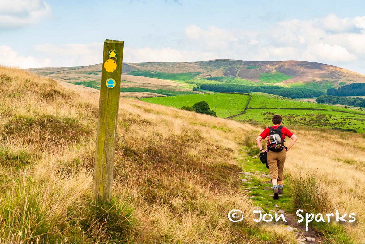
It's just a short way up by the road to the the top, where you strike off along the ridge on a good track. It's a feature of this walk that, not only are the gradients generally gentle but it's nearly always excellent underfoot. And this stretch gives views both sides, south to the now-familiar Sabden Brook and north to the Ribble Valley and the Bowland Fells beyond, with Ingleborough and Pen-y-Ghent further off to the north-east.
Beyond the shoulder of Apronfull Hill—a useful launching site for paragliders in a north-westerly wind—the ridge gradually spreads out, and you lose those northward views for a while. There's a brief look down the tight valley of Ogden Clough and just a glimpse of Pendle Forest beyond. It's this area, under Pendle Hill rather than on it, that is home to a rather darker tale than that of George Fox; the legend of the Pendle Witches.
I say 'legend', but the story has genuine historical underpinnings: in 1612 seven women and two men from Pendle Forest, around the villages of Newchurch-in-Pendle and Roughlee, were tried at Lancaster Castle, convicted of witchcraft, and hanged3. Some of them had confessed to practising witchcraft, but of course we know that not all confessions can be relied upon. It's impossible, today, to say whether any of them were real witches—if that even means anything.
The story has been dissected in many more-or-less factual books and retold as fiction more than once4; the definitive novel about the Pendle Witches is Robert Neill’s 1951 classic Mist over Pendle. The same legends are also part of the inspiration for Joseph Delaney's Wardstone Chronicles series, which began in 2004 with The Spook's Apprentice. Pendle Hill, and its surroundings, are certainly more storied than the average—and we haven't finished yet.
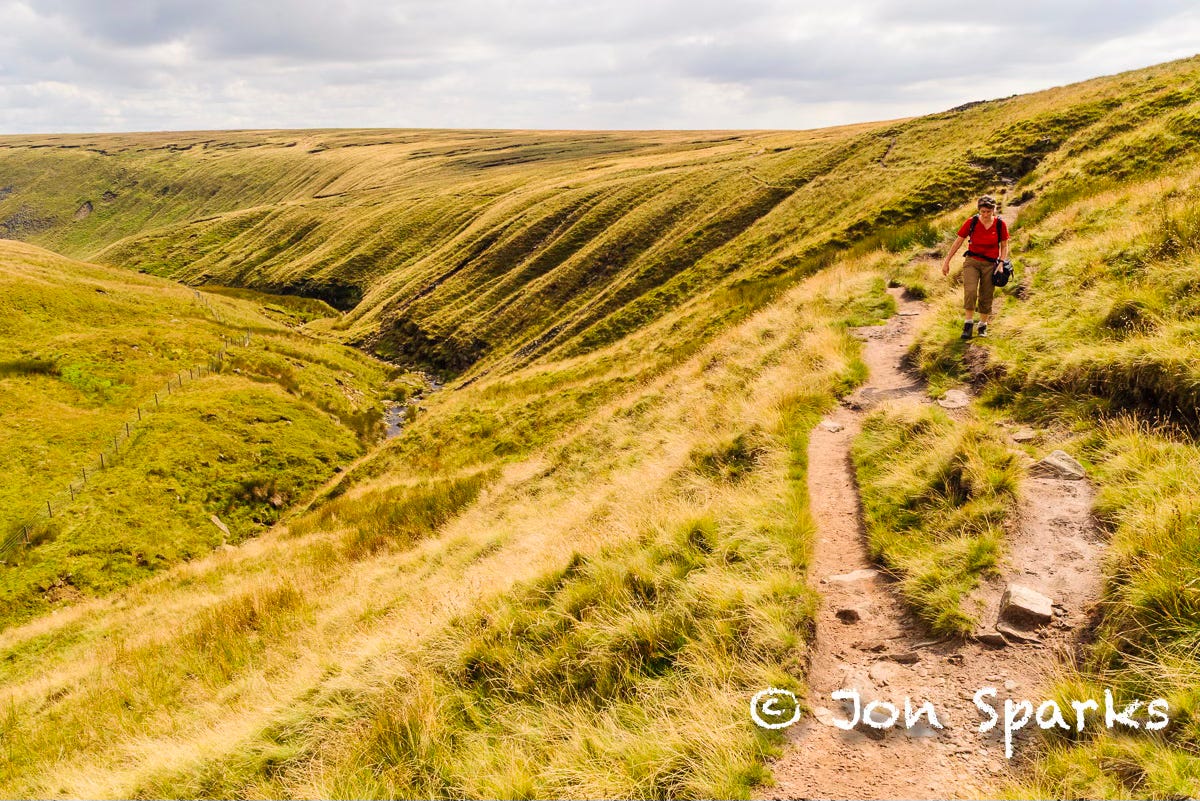
The broad track gives way to a narrow path scribed above the upper reaches of Ogden Clough, until it dips to cross the stream. A flagged path describes an almost straight course across sprawling upper slopes to the summit trig point.
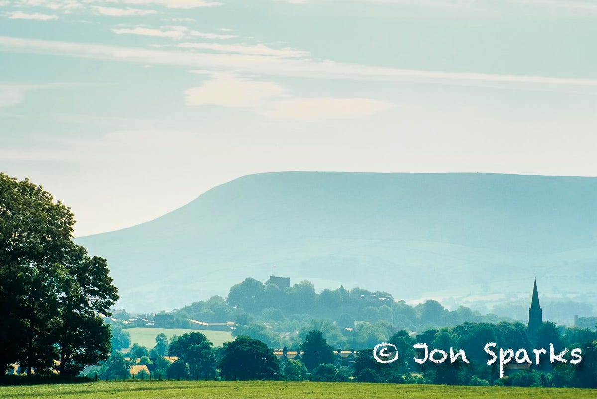
Just a few strides further east, the ground drops away suddenly, giving an almost aerial view of Barley and Pendle Forest. You can see at once just how steep the route from Barley is—'much adoe' indeed, but we've avoided all that. Beyond the Pendle Forest ridge you can now see the coalescent towns of Colne, Nelson, Brierfield and Burnley. Along with Clitheroe and Barnoldswick, and surrounding villages, at least 200,000 people can be said, pretty near literally, to live in the shadow of Pendle Hill. On the doorstep of so many, it's small wonder the summit area is rarely entirely deserted. But there's plenty of room to spread out.
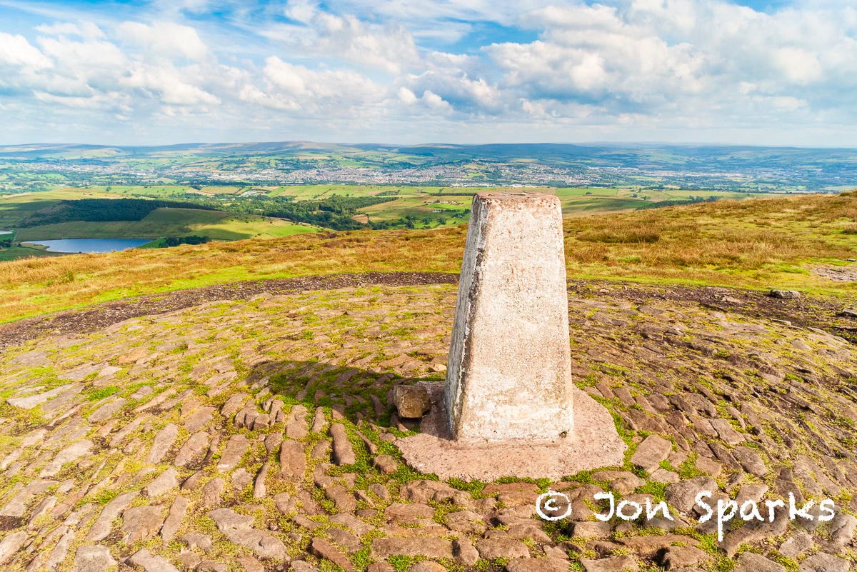
Here, at the highest point, is a good place to note one more of Pendle's claims to fame. The gentleman-scientist Richard Towneley of Burnley, with a colleague, Henry Power, used an early barometer to measure atmospheric pressure at various altitudes on Pendle Hill. Towneley and Power seem to have been the first to see a relationship between the density and pressure of air, though 'Mr Towneley's hypothesis' is now better known as Boyle's law. The observations were made in 1661: Pendle seems to have been a particularly lively place in the seventeenth century.
Our traversing route continues almost due north now, and soon we're winding down the steeps of Downham Moor. This is pretty near as steep as the infamous slope above Barley, but not for as long, and we are taking it in descent. The views this side are almost entirely rural, with the one blemish of the cement works on the edge of Clitheroe. The rest is the green of the Ribble Valley and the brown (or purple in August) of the Bowland Fells, and a considerable sweep of the Yorkshire Dales too, though Ingleborough and Pen-y-Ghent still stand out.
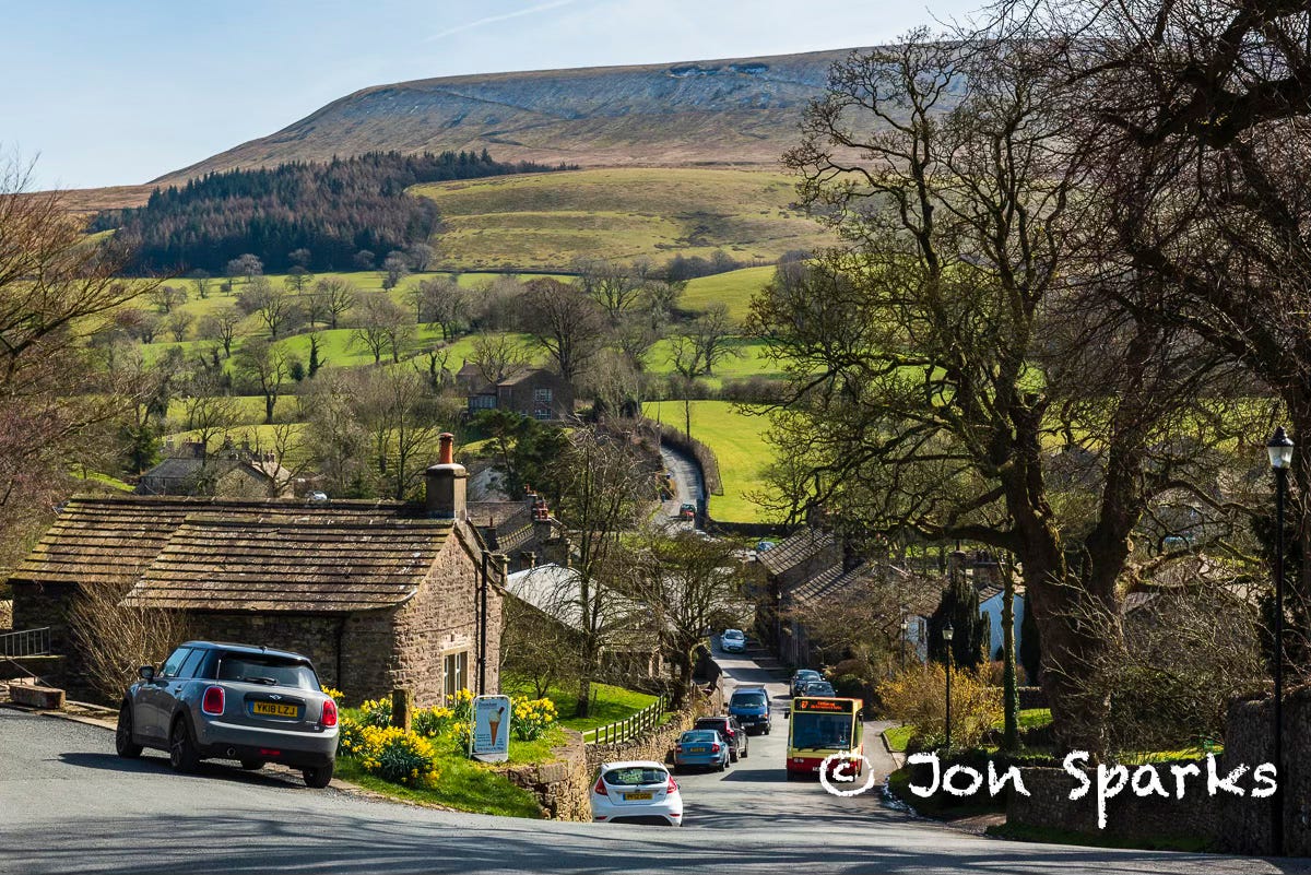
After a road-crossing, the route continues down fields to a pretty conclusion along a tributary stream and then Downham Beck before reaching Downham village. Lancashire has a lot of attractive villages, and the Ribble Valley claims more than its fair share, but Downham is one of the showpieces. It also trades off its use as a location for a number of film and TV productions, including the 1961 film Whistle Down the Wind and the BBC family series Born and Bred (aired 2002–2005). Downham is particularly suited for period dramas because—as you'll probably notice—there are no overhead cables, TV aerials, or satellite dishes. This restriction is enforced by the current Lord Clitheroe, who still has a house in the village.
If you thought you'd finished with ascent, however, there's a rude awakening as you confront the main street—nearly but not quite the only street. This is uphill, and steep near the top—and that's where both the pub and the bus stop are to be found. Well, nothing's perfect.
One more story. It's frequently related that Pendle Hill means ‘Hill Hill Hill’. We can easily imagine early Celtic inhabitants calling it simply ‘the Hill’: Pen. Later incomers, not understanding the meaning of the name, dubbed it Pendle, meaning ‘the hill called Pen’. This meaning too became obscured, and the name came to apply to the whole district.
Pendle Hill. So good they named it thrice.
Like to show support? You could…


The walk (from Whalley train station to the bus stop in Downham) is 15 kilometres, with 520 metres of ascent.
Full details and route notes available on request.
Whalley Warm & Dry: it’s still there.
A story well known to me from another angle as I grew up in Lancaster. I occasionally drank in the Golden Lion on Moor Lane, said to be where the condemned took a last drink before the long trudge up to the moor itself and the place of execution. The area is still known (and marked on Ordnance Survey maps) as Golgotha.
Including an episode of Doctor Who, aired about six months after this piece was first published. Obviously they didn’t nick the idea off me.
Lovely read. Not been up there for a while. Time to re-visit I think!
I so enjoyed this. I am ashamed to say I knew nothing of George Fox, and found this fascinating.